Copyright D.P. Browne 2011

ND : PLAN
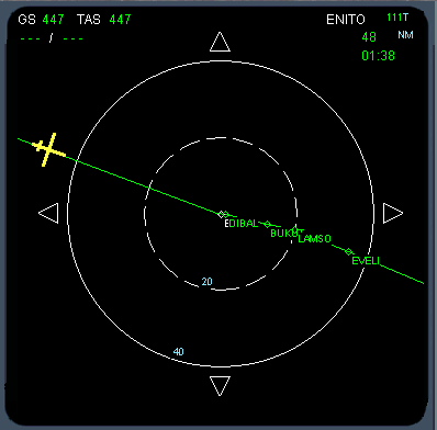
The Plan ND shows the flight plan in a North Up format. The center of the map is the waypoint currently showing at the top of the MCDU Flight Plan page.
To move along the flight plan the flight crew scrolls the flight plan up/down on the MCDU.
At the top left of each navigation displays there is the ground speed (GS), True air speed (TAS) and the wind direction and speed. The wind direction is shown with 3 digits always ( eg 005, 040, 123 ). An arrow under the wind direction and speed gives an indication of the direction relative to the aircraft’s heading.


At the top right of the ROSE, ARCH displays, the TO waypoint information is shown. This the the name of the waypoint, the distance and the expected time of arrival (ETA, in UTC ) at the waypoint.
The TO waypoint is the next waypoint in the flight plan the aircraft is flying towards.
Next
Previous


